
 Skip to navigation
Site Primary Navigation:
- About SDSC
- Services
- Support
- Research & Development
- Education & Training
- News & Events
Search The Site:

Published 08/08/2005

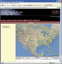
An automatically generated map displaying the service that monitors the status of the nodes of the GEON grid. |
But creating maps that are effective in communicating complex information takes considerable effort and skill, especially when the spatial data sets come in different formats, units, and projections, or reflect the diverse conventions used in different scientific domains. Finding a solution to these challenges becomes especially critical in large cyberinfrastructure projects such as the NSF-supported GEON project, "Cyberinfrastructure for the Geosciences," which is enabling the seamless integration of different scientific data sets in order to help geoscientists answer much broader questions across multiple disciplines than was previously possible.
To meet this need, researchers in the SDSC Spatial Information Systems Lab, directed by Ilya Zaslavsky, and other labs in the Science R&D Division, including Ashraf Memon, GEON Chief Software Engineer, Ghulam Memon, Research Programmer, and Kai Lin, senior SDSC staff, have developed a method for the on-demand generation of composite maps from sources that are semantically different, that is, use dissimilar terms and concepts.
"What's new in our approach is that it combines both GIS spatial information technology and semantic mediation technologies for finding and merging data," explained Zaslavsky. "This innovative mapping service lets researchers use powerful searches to explore and interact with large map and image collections as well as other kinds of data, even if the data collections are distributed across many sites."
Under the GEON project, SDSC researchers are developing comprehensive cyberinfrastructure that can be applied in multiple projects and disciplines, getting the most out of the development effort. "This advanced mapping service, which is helping GEON researchers view integrated geoscience information on maps, is already being used in other projects," said Chaitan Baru, coordinator of IT in GEON and director of SDSC Science R&D and the SDSC/Calit2 Synthesis Center.

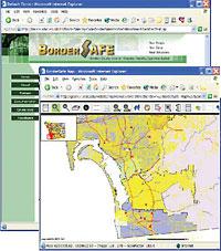
An example of mapping results returned from a query of a remote non-hosted database and a dynamically generated ArcIMS service, produced as part of the BorderSafe project. |
And who would have thought that mapping technologies could be applied in the apparently unrelated field of neuroscience? In the Brain Atlas component of the NIH Biomedical Informatics Research Network (BIRN) project, researchers have found that generating map services is a valuable way to provide neuroscientists with powerful query access to collections of large brain image files, which can be as big as two to four gigabytes. Once the neuroscience images are spatially registered to a common 3-D stereotaxic brain coordinate system, they are automatically exposed as map services, and neuroscientists can then ask questions about this data from their Web browsers. This is a clear example of the benefits that cyberinfrastructure research can bring, opening up opportunities to leverage technologies and create unforeseen synergies across very different scientific domains.
The mapping software works by making use of a set of grid services that produce composite maps, managing query rewriting, data conversion, and map assembly. The core of the technology is a map assembly service, which works alongside a spatial mediator to compose a new "map service" out of fragments obtained from individual spatial databases or standards-compliant map servers. This approach differs from traditional Internet mapping techniques which rely on static map services, and it offers important flexibility that is needed in handling complex scientific data. As part of the GEON project's services-oriented architecture, this mapping approach has also made it possible to incorporate additional services such as "smart" searching and data integration using ontology-based query rewriting and data transformation.
Additional projects are interested in making use of this innovative mapping technology, and the mapping service code is now being readied for distribution from the GEON Web site at www.geongrid.org. For more information, contact Ashraf Memon, amemon@sdsc.edu.