Skip to navigation
Site Primary Navigation:
- About SDSC
- Services
- Support
- Research & Development
- Education & Training
- News & Events
Search The Site:
Published 11/07/2011
The space shuttle program may have ended, but data collected by astronauts during the past three decades are still helping advance science, this time with the assistance of the Triton Resource, a supercomputer at the San Diego Supercomputer Center, an Organized Research Unit of the University of California, San Diego.
|
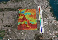
Solar power shortfalls due to elevation in the Twin Peaks neighborhood on a clear January day. (Image courtesy of Jan Kleissl, UCSD Jacobs School of Engineering) |
The researchers relied on SDSC's Triton Resource, which used 60,000 processor hours to run calculations to help create a new model that includes detailed elevation data. The model is being made available publicly on a large scale, including all of Southern California, as well as the San Francisco Bay Area. Utility companies and homeowners can use the model to get a more realistic picture of the solar power output they can typically expect to produce. This is an especially important tool for utilities, because it gives them a better idea of how much revenue they can actually generate, Kleissl said.
|
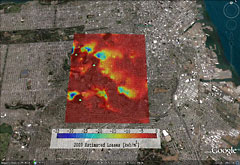
Solar power shortfalls due to elevation in the Twin Peaks neighborhood of San Francisco for one year. (Image courtesy of Jan Kleissl, UCSD Jacobs School of Engineering) |
For example, on clear winter days in San Francisco's Twin Peaks neighborhood, in the areas at the foot of the steepest hills, solar days are up to 30 percent shorter than on flat terrain. A solar power plant in that area would produce 12 percent less energy on those days than if it was located on a plain or other flat landscape. But in summertime, the days are much longer and the sun is brighter, so the total production shortfall would be only one to two 2 percent over the course of a whole year.
"Solar resource models have become very accurate," said Kleissl. "Now we are refining them down to the last few percentage points."
Bosch, the postdoctoral researcher, used elevation data obtained on a near-global scale by astronauts aboard the space shuttle Endeavour during an 11-day mission in February, 2000. The data were later compiled into a high-resolution digital topographic database of most of planet Earth. Bosch and Kleissl focused on the areas of California where most solar power plants are located and where elevation is an issue, namely the San Francisco Bay Area and Southern California, including San Diego, Imperial, Riverside, Orange, and Los Angeles counties.
One caveat for the method developed by Kleissl and Bosch is that it provides only baseline information in urban areas. Trees, poles, and other rooftop structures, such as chimneys, can cause more power losses. In that case, the best method to estimate power shortfalls is to use a fisheye camera to visualize the local horizon, a device that any qualified installer of solar panels would have on hand.
Full details of Kleissl and Bosch's study can be found online. The horizon data will be made available as a simulation option in Clean Power Research's SolarAnywhere product line as early as the first quarter of 2012. The horizon data (50 GB of csv files) will also be publicly available at the California Solar Initiative website and upon request from jkleissl@ucsd.edu
|
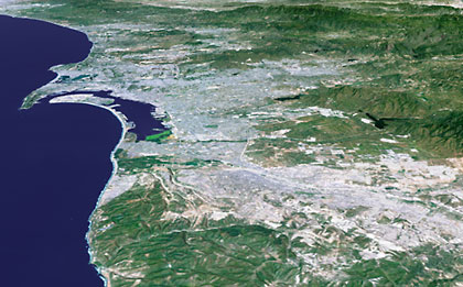
Researchers used 3D models captured by the Shuttle Endeavor, like this one, showing the San Diego area. (Image courtesy of JPL/NASA). |
Media Communications Contacts
:
Ioana Patringenaru, UC San Diego Jacobs School of Engineering
858 822-0899 or
ipatrin@ucsd.edu
Jan Zverina, SDSC Communications
858 534-5111 or
jzverina@sdsc.edu
Warren R. Froelich, SDSC Communications
858 822-3622 or
froelich@sdsc.edu
SDSC:
http://www.sdsc.edu/
Jacobs School of Engineering:
http://www.jacobsschool.ucsd.edu/
Kleissl Solar Resource Assessment and Forecasting Lab:
http://cer.ucsd.edu/pages/kleissl.shtml/
UC San Diego:
http://www.ucsd.edu/