
 Skip to navigation
Site Primary Navigation:
- About SDSC
- Services
- Support
- Research & Development
- Education & Training
- News & Events
Search The Site:

Published April 24, 2019

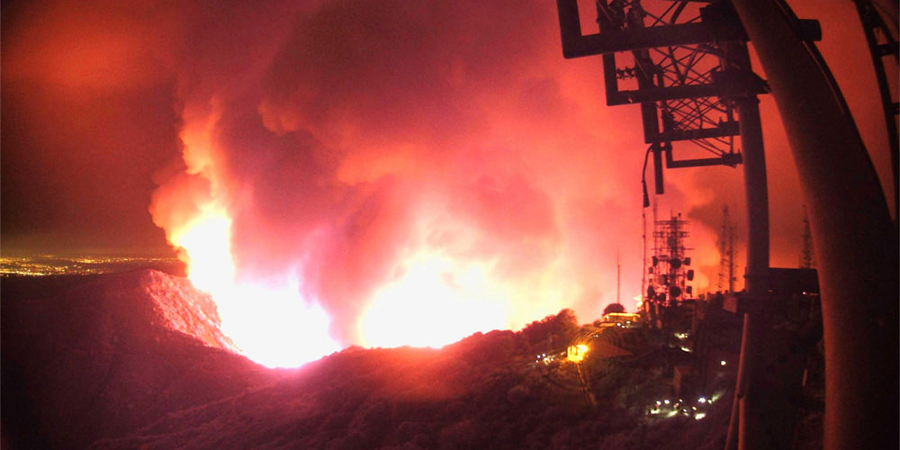
Multiple first-responder agencies and organizations rely on HPWREN’s camera network across remote areas of greater San Diego. HPWREN users met in April to discuss the future of not only these “virtual fire towers” but also additional applications of the high-speed network. Credit: HPWREN
By Kimberly Mann Bruch, SDSC Communications
On August 6, 2018, first responders received a 911 call reporting a fire. A quick check of a set of recently deployed fixed field of view cameras confirmed the presence of smoke, immediately followed by pointing the new ALERTWildfire PTZ cameras on Santiago Peak to confirm the fire’s location within the Cleveland National Forest and its significant potential for major destruction. Notifications were sent to the applicable agencies.
That fire became known as the Holy Fire, which burned 23,136 acres and was finally contained more than a month later, on September 13. The new cameras were deployed less than four months prior in partnership with ALERTWildfire, the Orange County Fire Authority, Southern California Edison, and UC San Diego’s High Performance Wireless Research and Education Network (HPWREN).
“Because we were able to determine post-fire that the smoke produced in the incipient phases of the Holy Fire was visible on these cameras prior to the initial 911 call, we plan on using this technology as ‘virtual fire towers’ in the future on identified high-hazard days to increase situational awareness,” said Brian Norton, Division Chief – Special Operations, Orange County Fire Authority. “This will be done in partnership with volunteer fire watch patrols already established in Orange County.”
Norton and fellow HPWREN users – ranging from astronomers at Palomar Observatory to networking engineers at the Tribal Digital Village Network (TDVNet) – recently participated in a wide-ranging workshop held at the observatory to update colleagues on current projects and discuss future plans for the network. The meeting was organized by Hans-Werner Braun, HPWREN co-founder and a research scientist at the San Diego Supercomputer Center (SDSC), and Frank Vernon, HPWREN co-founder and a research geophysicist at Scripps Institution of Oceanography, who welcomed workshop attendees with a briefing on HPWREN’s status and projections.
Vernon focused his discussion on the importance of HPWREN within the science, education, and first responder communities, as well as an array of agencies including San Diego Gas and Electric (SDG&E), San Diego County Fire Authority, California State Parks, Orange County Fire Authority, as well as WIFIRE, a National Science Foundation (NSF) funded project led by UC San Diego that has developed real-time and data-driven simulation, prediction, and visualization of wildfire behavior.
Vernon explained the involvement of the multi-partner Pacific Research Platform (PRP) which supports HPWREN, and how the CENIC 100 Gigabit optical fiber is used to link HPWREN data servers at UC San Diego, San Diego State University, and UC Irvine. Once a wildfire is spotted by the HPWREN-connected cameras, PRP delivers high-resolution weather data to fire modeling workflows in WIFIRE.
Following Vernon’s talk, the workshop’s keynote address was given by Andy Boden, deputy director at the Caltech Optical Observatories (COO), which oversees the administration of the Palomar Observatory. Boden commended the network for assisting in several major discoveries, including the 2005 discovery of Eris, a dwarf planet.
“Thanks to discoveries aided by HPWREN, astronomers came to understand that Pluto belonged to a different dynamical family than the other things that we call ‘planet’,” explained Boden. “Hence, the 2006 IAU definition ‘demoted’ Pluto to what we call a minor planet.”

[Enlarge] An important extension of HPWREN is the Area Situational Awareness for Public Safety Network (ASAPNet) program, a partnership between the County of San Diego, the California Department of Forestry and Fire Protection (CAL FIRE), the United States Forest Service (USFS), San Diego Gas and Electric (SDG&E), the University of California San Diego (UCSD), and San Diego State University (SDSU). Credit: San Diego County Fire Authority
Jerald Coleman, technology manager at the San Diego County Fire Authority, which is one of the primary supporters of HPWREN, spoke about the Area Situational Awareness for Public Safety Network (ASAPNet) - a public/private partnership-based extension of HPWREN for the benefit of public safety communities, especially firefighters in San Diego County. Coleman discussed how ASAPNet partners such as SDG&E are currently planning to build out wireless internet data communications capabilities to further firefighter assets, while also using HPWREN’s environment-observing cameras and other sensors.
Chris Arends, meteorology program manager at SDG&E, another primary HPWREN supporter, discussed the importance of the HPWREN-connected cameras, the weather stations, and the resilience of the HPWREN system. Arends noted that the weather stations, which report data every 10 minutes, is ingested into their weather modeling system and imperative to their efforts.
Additional speakers included:
Presentations are available at http://hpwren.ucsd.edu/Presentations/20190404-HPWREN_Users_meeting/.
About HPWREN
For almost two decades, HPWREN has connected hard-to-reach science, education, and first responder sites to reliable broadband communications systems. Originally based at SDSC and Scripps Oceanography and funded in 2000 by the National Science Foundation (NSF), HPWREN has since transitioned to a user-funded system and has grown to cover hundreds of miles throughout southern California’s most rugged terrain.
About SDSC
As an Organized Research Unit of UC San Diego, SDSC is considered a leader in data-intensive computing and cyberinfrastructure, providing resources, services, and expertise to the national research community, including industry and academia. Cyberinfrastructure refers to an accessible, integrated network of computer-based resources and expertise, focused on accelerating scientific inquiry and discovery. SDSC supports hundreds of multidisciplinary programs spanning a wide variety of domains, from earth sciences and biology to astrophysics, bioinformatics, and health IT. SDSC’s petascale Comet supercomputer is a key resource within the National Science Foundation’s XSEDE (eXtreme Science and Engineering Discovery Environment) program.
Share