|
Geology and Geography
A Misshapen Worldlet
The Red Planet
 or the past half-dozen years, Mike Bailey has been a pioneer in using rapid prototyping fabrication machines for science, creating stunningly accurate replicas of complex molecules, human bones and internal organs, mechanical parts, geophysical terrain, and other three-dimensional subjects. Researchers across the nation and students in his computer science and engineering courses value his solid visualizations as unique tools for scientific discovery. One set of his models deals with the largest solid objects of all–entire planets. From our own Planet Earth to other worlds in our solar system, the models from SDSC’s Design Visualization Laboratory have intrigued and excited space scientists, geologists, cartographers, geophysicists, and educators. "You can hold these models, touch them, look at them from any angle," Bailey said. "They really give you a sense of physical structure in a way that images on a screen just can’t convey. This is planetary geology made real." or the past half-dozen years, Mike Bailey has been a pioneer in using rapid prototyping fabrication machines for science, creating stunningly accurate replicas of complex molecules, human bones and internal organs, mechanical parts, geophysical terrain, and other three-dimensional subjects. Researchers across the nation and students in his computer science and engineering courses value his solid visualizations as unique tools for scientific discovery. One set of his models deals with the largest solid objects of all–entire planets. From our own Planet Earth to other worlds in our solar system, the models from SDSC’s Design Visualization Laboratory have intrigued and excited space scientists, geologists, cartographers, geophysicists, and educators. "You can hold these models, touch them, look at them from any angle," Bailey said. "They really give you a sense of physical structure in a way that images on a screen just can’t convey. This is planetary geology made real."
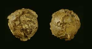 |
Figure 1. Our Irregular Earth
The vertical relief on this bowling-ball sized globe of our planet has been exaggerated by a factor of 100, emphasizing continents, mountain ranges, subduction trenches, and rifts. |
Bailey established SDSC’s TeleManufacturing Facility in 1995 based on a computer-controlled Laminated Object Manufacturing (LOM) fabrication machine. The LOM cuts hundreds of layers of paper to match the outlines of consecutive slices through a solid object, and automatically stacks and glues these cross-sectional slices together. The resulting solid models look and feel like wood.
Two years ago Bailey acquired a second rapid-prototyping machine, a Z402 from Z Corporation. "The manufacturer calls it a ‘3-D printer,’" Bailey said, "because it uses ink-jet printer technology." A computer-controlled print jet sprays liquid binder–glue–into layers of fine powder similar to plaster of Paris and eventually forms a full, three-dimensional object from the cemented powder. "Additional jets can spray colored dyes into the powder along with the binder," Bailey explained, "so we can even produce models in full color."
Recently Bailey has transitioned both machines into SDSC’s new Design Visualization Laboratory. Researchers across the country can send geometry files to the lab to be rendered as solid models.
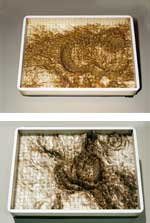 |
Figure 2.
Subduction at Work?
Working with David Sandwell of Scripps Institution of Oceanography, Bailey created a models of a corona on Venus (top) and a curved subduction zone in the South Atlantic that may have been formed by similar processes. |
Geology and Geography
Geologist Eric Frost and his colleagues at San Diego State University use 3-D terrain models in their scientific and educational activities. "Eric and I have worked for several years on projects in which he supplied the data or assisted with extracting it from databases of terrains and geological provinces," said Bailey, who is both an SDSC Senior Principal Scientist and an adjunct professor at UC San Diego. "Some features have to be seen from just the right angle to be visible. Whenever researchers get new models from the machine, they almost always see something they don’t notice on a monitor,"
In 1998, Bailey tackled a larger subject–the entire planet Earth. The LOM model is a globe the size of a bowling ball (Figure 1), with the vertical relief of the land and seafloor topography exaggerated for effect. The Earth’s elevation range of 8.79 miles below sea level to 5.95 miles above are mapped into 1.5 inches of relief. The model weighs nine pounds and took 51 hours to construct.
"The fundamental concepts of geology become perceptible and palpable," Frost said. "If we look at the whole world, we can see that the plate boundaries determine the grand lines of coastal regions. ... The history of the Earth’s lithospheric plates is written in the grand arcs of the world’s coastlines, where oceanic plates are often in the process of subducting beneath plates carrying continents."
Bailey extended the reach of the LOM to a second planet when he worked with David Sandwell of Scripps Institution of Oceanography to model a section of the surface of the planet Venus (Figure 2), a region called a corona that some researchers believe analogous to a tectonic plate subduction zone on Earth. "Sandwell took the Venus model and a model of the curved subduction zone between South America and Antarctica to a geophyisical conference," Bailey said. "He pointed out their similarities in his talk, and I think he persuaded a lot of researchers."
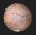 |
Figure 3. The Red Planet
Space scientist Michael Malin supplied the color and terrain data for this globe of Mars. The enormous Olympus Mons volcano, the size of Arizona and 15 miles high, protrudes from the side of the planet with vertical scale exaggerated 25 times. The Valles Marineris canyon complex at center would span the width of North America if it were on Earth. |
A Misshapen Worldlet
Bailey’s next model of an entire world looks like nothing so much as a wooden replica of a large, somewhat misshapen potato, but space scientists at Cornell University, Johns Hopkins University’s Applied Physics Laboratory, and JPL loved it. It’s a scientifically accurate LOM rendering of the asteroid Eros.
Bailey began working with planetary scientists on the effort in early 1999. The Near Earth Asteroid Rendezvous (NEAR) spacecraft had just flown past the asteroid Eros, taking the first detailed photographs of the 20-mile-long object. From these images, Cornell researchers created a 3-D map database for mission planning purposes. But Eros is anything but a simple sphere, which complicated the tasks of navigating in orbit around the "space rock" and aiming its camera and instruments at selected areas of its surface.
Cornell’s Brian Carcich contacted Bailey and sent him the surface definition data file to see whether a model would be feasible to make. The answer arrived in the mail only a few days later–a solid model of the asteroid. The preliminary model wound up in a place of honor on the desk of NEAR mission manager Robert Farquhar.
On February 14, 2000, the spacecraft encountered Eros again and went into orbit around it a few dozen miles from the surface. When the entire surface of the asteroid had been charted, Carcich sent Bailey the new geometry files and the LOM began turning out high-accuracy asteroid models. Several were distributed to members of the scientific and planning teams at Cornell , Johns Hopkins, and JPL for mission planning. Others were delivered to space scientist Mike Malin, a member of the NEAR Multispectral Imager/Near Infrared Spectrometer team at Malin Space Science Systems in San Diego.
The Red Planet
Under contract to JPL, Malin’s group designed and currently operates the camera on the Mars Global Surveyor spacecraft that orbits the Red Planet. The company has acquired a vast amount of image data, and Malin is an expert on Martian geology. He quickly became enthusiastic about the prospect of making terrain models from data acquired by Mars Global Surveyor.
Malin supplied data sets that define the martian surface, accurate to within a few meters in resolution, derived both from Mars Orbiter Camera images and from an ultra-accurate laser altimeter on board the spacecraft. "In almost every way, Mars now is more accurately mapped than Earth," Malin said.
Malin and Bailey’s initial project was to construct two models of geologically interesting regions of Mars–the Valles Marineris canyon complex and a section of cratered terrain. When Bailey handed the models to Malin, the space scientist pointed out regions of the terrain that had been scarred by meteorite impacts, covered by lava flows, or eroded by enormous floods. Malin–along with many other scientists who have studied the issue–believes that water from subsurface sources was a significant factor in shaping the Martian landscape.
"Look at this channel, called Shalbatana Vallis," he noted, pointing to a feature on the model. "It was clearly formed by fluid erosion. But it starts at a single large depression, without a system of smaller tributary channels into it. Look ... here’s something that’s difficult to see unless you have a model. The floor of that depression is at the same level as the far end of the channel, and the intervening ground is higher. That type of relief is very difficult to create without the intercession of groundwater."
Soon after the Z402 gained color capability, Malin supplied the data set for the topography of the entire planet. Bailey set the device to work. The result was a color replica of the planet Mars (Figure 3). Surface relief is exaggerated by a factor of 25. Even at the scale of a four-inch model representing a planet four thousand miles in diameter, the globe shows an abundance of surface features, including the Olympus Mons and Tharsis Rise volcanoes, the enormous Valles Marineris canyon complex, flood plains, craters, asteroid impact basins, the polar icecaps, and color variations of the terrain.
Bailey and Malin plan to build larger models of Mars. "We’d like to work our way up to a really big model, several feet across and constructed in sections," Malin said. "A large, accurate relief globe of Mars would be a unique scientific asset."
Bailey anticipates modeling other planets as soon as he acquires their surface definition files, and he hopes to receive global and local databases for the Moon and Venus soon.
"These models are serious research tools, and scientists are eager to get their hands on them," Bailey said. "We’re not building these models because they’re cool–even though they are–but because scientific insights can be gleaned from them that aren’t available by any other means." –MG 
|
PROJECT LEADER
Michael J. Bailey
SDSC
|

 Skip to navigation