
 Skip to navigation
Site Primary Navigation:
- About SDSC
- Services
- Support
- Research & Development
- Education & Training
- News & Events
Search The Site:
Published 07/14/2008
For Immediate Release
|
|
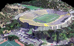
A 3D view of a high-resolution digital elevation model of the California Memorial Stadium at the University of California, Berkeley, overlain with color aerial photography. In addition to being a powerful tool for studying fault zones (Memorial Stadium was built on the Hayward Fault), LiDAR data also provides a detailed representation of buildings and vegetation that are of interest to many different user communities. The GEON LiDAR distribution and processing system provides simple, internet-based access to the GeoEarthScope LiDAR dataset via the GEON portal at the San Diego Supercomputer Center.
|
Media Contacts:
Jan Zverina, SDSC Communications
858 534-5111 or
jzverina@sdsc.edu
Warren R. Froelich, SDSC Communications
858 822-3622 or
froelich@sdsc.edu
All data acquired by the GeoEarthScope Northern California Airborne LiDAR project are now available for download to researchers, engineers, planners, students, and others via the GEON portal at the San Diego Supercomputer Center (SDSC) at UC San Diego.
The GeoEarthScope Northern California LiDAR (Light Detection And Ranging) project acquired high resolution topography data starting in spring 2007, along major active geologic faults in the western United States as part of the EarthScope Facility project funded by the National Science Foundation (NSF). Between this project and the previously conducted B4 project in Southern California, also funded by NSF, the entire San Andreas fault system and associated geologic features have now been mapped with high-resolution airborne LiDAR. This was the first in a series of large-scale GeoEarthScope LiDAR acquisition projects.
Earlier this year, extensive high-resolution LiDAR data for active faults in southern and eastern California and the Pacific Northwest were acquired. Features included in this acquisition include the Garlock and Elsinore faults in California and the Yakima Fold and Thrust Belt in Washington. These data are currently being processed and will be available this fall via the GEON portal, based at the San Diego Supercomputer Center on the UC San Diego campus. The final GeoEarthScope LiDAR field campaign is in progress this month, with the goal of acquiring data for features in Yellowstone National Park, the Tetons, the Wasatch Front and Alaska.
"Providing online access to large scientific data sets, along with rich data processing, analysis, and visualization services, is the direction for the future, as much of science becomes data intensive in nature and dominated by the need for high-performance data processing," said Chaitan Baru, SDSC Distinguished Scientist and overall principal investigator for the GEON, an NSF-funded collaboration among a dozen PI institutions, including SDSC, and a number of other partner projects, institutions, and agencies to develop cyberinfrastructure in support of an environment for integrative geoscience research.
"The GeoEarthScope LiDAR data provide an unprecedented representation of the topography along many active faults in the western United States and will be a phenomenal resource for researchers studying earthquake hazards, faulting, and tectonics in that region," said Christopher Crosby, manager of the GEON LiDAR project at SDSC. "The GEON LiDAR system utilizes cyberinfrastructure capabilities developed at SDSC to provide internet-based access and processing of these massive and computationally challenging datasets to a large and diverse scientific user community."
GeoEarthScope, a component of the NSF-funded EarthScope project, includes the acquisition of aerial and satellite imagery and geochronology. It is managed by UNAVCO, a non-profit, membership-governed consortium that supports Earth science by advancing high-precision techniques for the measurement and understanding of crustal deformation. GeoEarthScope is conducted in partnership with the U.S. Geological Survey (USGS) and the National Aeronautics and Space Administration (NASA).
Download Details
|
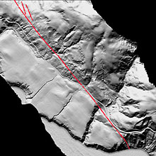
| A half meter resolution digital elevation model of the San Andreas fault zone near Fort Ross, Sonoma County, Calif., produced from GeoEarthScope LiDAR topography data. In this image, filtering has been used to remove the vegetation from the dataset resulting in "bare earth" terrain model. The red line shows the approximate location of San Andreas fault ground rupture that occurred during The Great 1906 San Francisco Earthquake. Distributed via the GEON portal at the San Diego Supercomputer Center, GeoEarthScope LiDAR topography offers an unprecedented opportunity to study earthquake producing faults, tectonics, and other geologic processes at resolutions not previously possible.
Credit: Christopher Crosby, SDSC Source: San Diego Supercomputer Center, UC San Diego. |
To access these data, go to the GEON web site at www.geongrid.org . Once a user account is opened, log in and select the "LiDAR" tab at the top of the page. Next, choose the "GeoEarthScope Northern California LiDAR Project (NoCAL)" link in the list of datasets. Users may select the tiles two ways: use the Google Maps-based interface accessible in the GEON Portal, or download the updated KML file from the GEON Portal and use it in Google Earth. Both approaches allow users to browse the dataset extent, make selections, and then download tiles of interest. Point cloud data access and custom DEM generation are available by choosing the point cloud option under "Download Options" at the top of the NoCal GeoEarthScope portal page. Please contact Christopher Crosby at the San Diego Supercomputer Center if assistance is required.
About GEON
The Geosciences Network (GEON) is an open collaborative project that is developing cyberinfrastructure for the integration of three- and four-dimensional earth science data. GEON is funded by the NSF's Information Technology Research (ITR) and Geoinformatics programs.
About SDSC
As an organized research unit of UC San Diego, SDSC is a national leader in creating and providing cyberinfrastructure for data-intensive research. Cyberinfrastructure refers to an accessible and integrated network of computer-based resources and expertise, focused on accelerating scientific inquiry and discovery. SDSC is a founding member of the national TeraGrid, which has a combined compute capability approaching one petaflop (10^15 calculations per second), or equal to the computing power of about 200,000 typical laptops.
San Diego Supercomputer Center (SDSC):
www.sdsc.edu
Geosciences Network (GEON) project:
www.geongrid.org
National Science Foundation:
www.nsf.gov
TeraGrid:
www.teragrid.org